บทนำ Mt Olympus topoguide
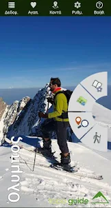
Mt Olympus topoguide is a digital field guide for hikers and nature lovers. It includes routes, descriptions and photos for 61 hiking trails, as well as tons of information on the unique nature of the highest Greek mountain.
Mount Olympus (2918 m) is no only the highest, but also the most importan mountain in
Greek history, related to the Greek identity itself. Its summits are very difficult to access and they have been climbed for the first time as late as 1913.
The application Mt Olympus topoguide offers detailed offline maps and an extensive introduction on geography and the paths of Mount Olympus, including a large chapter on the mountain's nature and a entensive presentation of its unique flora and fauna.
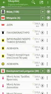
The app offers also a useful list of POIs with a comprehensive search engine.
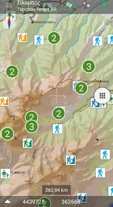
The trails list includes easy and moderate hiking trails, as well as tenths of very difficult, challenging mountaineering routes, of a total length of 550 km.
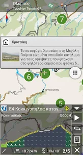
In the field, the app identifies the nearest adventure, guides you to it and then along it by displaying messages and warnings on every junction or other important location. On each Point of Interest, photos and texts are displayed on the map. If the hiker gets off-trail, the app indicates the shorter way to get back safely.
The cartographic company AnaDigit, creator of the application, has issued previously hundreds of detailed hiking maps for Greece (eg. maps of Menalon Trail, Mt. Olympus, Crete, Zagori, Sifnos, Naxos and other Aegean islands). To build the application and ensure data accuracy, all paths of Mt Olympus have been revised during Summer 2020.
Mount Olympus (2918 m) is no only the highest, but also the most importan mountain in
Greek history, related to the Greek identity itself. Its summits are very difficult to access and they have been climbed for the first time as late as 1913.
The application Mt Olympus topoguide offers detailed offline maps and an extensive introduction on geography and the paths of Mount Olympus, including a large chapter on the mountain's nature and a entensive presentation of its unique flora and fauna.
The app offers also a useful list of POIs with a comprehensive search engine.
The trails list includes easy and moderate hiking trails, as well as tenths of very difficult, challenging mountaineering routes, of a total length of 550 km.
In the field, the app identifies the nearest adventure, guides you to it and then along it by displaying messages and warnings on every junction or other important location. On each Point of Interest, photos and texts are displayed on the map. If the hiker gets off-trail, the app indicates the shorter way to get back safely.
The cartographic company AnaDigit, creator of the application, has issued previously hundreds of detailed hiking maps for Greece (eg. maps of Menalon Trail, Mt. Olympus, Crete, Zagori, Sifnos, Naxos and other Aegean islands). To build the application and ensure data accuracy, all paths of Mt Olympus have been revised during Summer 2020.
เพิ่มเติม